 What’s the old expression? When in Rome do as the Romans do, right? What about the Romans from centuries ago?
Many tourists visit Rome because they are interested in its rich history and plan to visit such iconic spots as the Coliseum and the Forum of Caesar, but there’s only so much you can see with the naked eye. Picturing the daily life and times of those who those who lived here before as they traveled from place to place is often left to our active imaginations. They didn’t have smartphones, cars, trains and even planes to rely on. Oxcart, donkey or horse anyone?
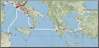
Fortunately, Stanford University’s researchers have created an ORBIS mapping program to bring the transportation history of Ancient Rome to life. It allows users to see what travel throughout the Roman road network — including rivers and seas in the Mediterranean, Black Sea and coastal Atlantic — would have been like.
The program lets you choose specific routes that intrigue you. For example, you can choose Smyrna to Vienna, and then choose the month you want to travel, the mode of transportation, and whether you want the fastest, cheapest, or shortest route. You will learn that the fastest journey from Smyrna to Vienna in July took 102.2 days by foot, covering 2988 kilometers. That same trip, but using a horse, cut the time down to approximately 55 days.
ORBIS includes more than 750 settlements, 4 million square miles of space, 50,000 miles of land routes, 20,000 miles of inland waterways (rivers and canals) and nearly 1,000 routes among sea ports.
By Kathy McCabe